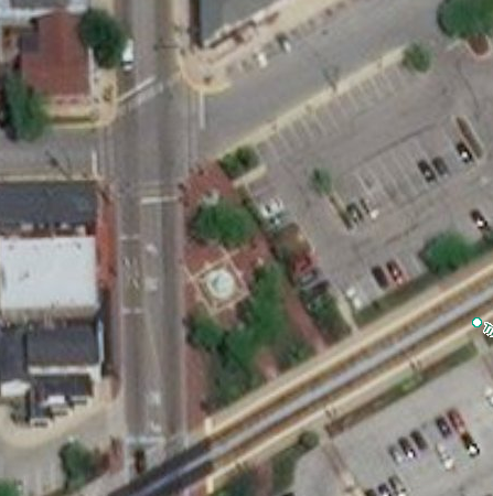
1. Civic Plaza Downtown - Marquette & 4th St.
Civic Plaza, Albuquerque, was built on two downtown blocks in 1972. By then, downtown had become New Mexico’s most developed downtown area, having sprung from the Santa Fe Railway’s local arrival in 1880. Before Civic Plaza's construction, an important highway ran through here. New Mexico Route 1, later the first local alignment of Route 66 and US 85, passed north-south through this space along Fourth Street. Today that ex-roadway is a promenade joining Marquette and Tijeras Avenues north and south of Civic Plaza.
From the north side of Civic Plaza (Marquette Avenue), go west on Marquette past City Hall to 5th Street. At the corner of 5th and Marquette, find the bronze trail marker in the sidewalk. Its Old Town arrow points north across Marquette: cross the street and continue northward to Roma Avenue. At 5th and Roma find a marker pointing west: cross 5th and follow Roma westward. Follow the arrows on these markers all the way to Old Town. Markers appear at each street corner along the route.
2. Law Office Complex - 505-09 Roma NW
A 1960-something, sub-urban sort of building, this office court seems out of place so near the center of the city. The brick-clad drum at the rear appears to have flown downtown and landed on a concrete stand, shading the parking area below. Its round shape creates a dilemma: there's no corner office for a company's chief executive.
3. Lew Wallace Elementary School - 513 6th NW
Built in 1934, it's the first of many New Mexico projects of the Public Works Administration, a federal New Deal program to counteract the Great Depression of 1929-1942. Lew Wallace, a US Army general during the mid-19th century, governed the New Mexico Territory from 1878 to 1881. He's better known for writing the Biblical-era historical novel, Ben Hur.
4. W.E. Mauger House- 701 Roma NW
Hardware dealer and wool buyer W.E. Mauger bought the house in 1907, less than five years after its construction. He and partner H.P. Raabe sold domestic and agricultural hardware and supplies to residents of Albuquerque and its trade area.
Now a bed-and-breakfast inn, the house was thoroughly renovated after its 1984 listing in the National Register of Historic Places.
5. Fourth Ward Historic District- Roma & Keleher St.
Roma Avenue enters the Fourth Ward Historic District at Keleher Street. One of Albuquerque's most valued, this house-dominated district mixes large, period-revival houses, bungalows and cottages with a fine collection of trees and shrubs. Professionals, politicians, stockmen and captains of local industry, from sawmill owners to the founders of a clinic and health care plan, lived here among merchants and office workers. Named for one of the four political subdivisions of the City of Albuquerque, incorporated in 1891, the historic district stretches south to Central Avenue and north to Lomas Boulevard.
6. William Lyon House - 901 Roma NW
Dr. William Lyon supervised construction of the house’s first adobe rooms in 1882 while corresponding with his fiancee, Corie Bowman of Mesilla Park in southern New Mexico. They married soon after. His pre-nuptial letters to Corie cover topics from house-and-garden progress to the relationship between theology and the theory of evolution.
7. Whitmer-McKinnon House - 504 Luna Boulevard NW
Family residence, rest home, maternity center– this house has changed in use since construction in 1920 by Thaddeus Whitmer, lumber mill owner. His widow, Mary, kept the mill and house after his death in 1931. The Daniel McKinnon family bought the house in 1944 and stayed until 1967. McKinnon was a surgeon and partner in Albuquerque’s Lovelace Clinic, which in 1959 examined America's first astronaut candidates in Project Mercury.
An original patio remains at the center, open to the sky. Returned to residential use since 1983, the house's non-original garage matches its Spanish-Pueblo Revival style, and drought-resistant plantings complete the picture.
8. Kate Nichols Chaves House- 501 11th NW
This Tudor Revival Style house of 1909, Albuquerque's earliest documented architectural design by a woman, carries her name. Daughter of an English-born architect, Kate Nichols married Amado Chaves, a lawyer, politician and New Mexico's first superintendent of public instruction. She designed and supervised construction of the house, then drafted more designs in its upstairs study, though this seems to be the only one built. Mrs. Chaves died unexpectedly in 1914 and was survived by Mr. Chaves and their three children.
Today the house and grounds are shaded by American elm trees and amount to a landmark of Judges' Row, where, on 11th and 12th streets, several lawyers and jurists lived during the early 20th Century.
9. Trumbull-Hesselden House- 1211 Roma NW
Built by Walter Trumbull in 1882, when few houses stood between Old Town and the rail line to the east at New Albuquerque, this was an imposing duplex. Inside, two of the two-story units share a central stair leading to a surprisingly spacious attic. An 1886 bird's-eye view of Albuquerque shows the house with a windmill behind.
Home to the Goss Military Institute for some of the 1890s and then the Hesselden family, the house was rented later as apartments. Once again a family’s residence, its crannies yield treasure: homework assignments written by Goss cadets, a child’s paper doll from the 1940s, and pieces of newspapers from as early as 1896.
The mansard style roof and sandstone walls are rare in Albuquerque houses. After 1880, the railroad connected the city with quarries to its east and west, but even so, few stone-walled buildings were ever erected here.
10. Stamm House- 323 13th NW
Built in 1912 for Mr. and Mrs. Roy Stamm, the details of this bungalow reflect the arts and crafts movement of the day. New Mexico attained statehood that same year. Mr. Stamm prospered in the wholesale fruit business and found adventure in early airplanes, balloons and automobiles. His articles for New Mexico Magazine praised fishing, skiing, and camping. The title of his autobiography, For Me, The Sun, affirms his love of New Mexico's climate.
11. Mary Fox Park- Roma and 14th St.
The park's winding path bends the trail from westbound Roma Avenue to northbound 14th Street. For a breather, linger under the arbor and reflect on the generosity of Mary Fox, who saw to the making of this place.
You're halfway to the Old Town Plaza.
12. JJ Megs House - 323 14th NW
This eclectic delight in stucco with red and green tile recalls the state question of New Mexico—"Red or green?," as in which kind of chile do you prefer on your enchiladas?
« TURN LEFT AT 14TH & LOMAS
Go West along the South side of Lomas Boulevard
13. Federico Armijo's Sculpture- Lomas & 14th St.
Its name, “Formas Esperando Palabra de Otros Mundos,” is Spanish for “Forms Waiting for Word from Other Worlds”. This sculpture was funded by the City’s 1% for the Arts program.
Nearby Historic Districts
North and south of Lomas Blvd., 16th Street leads into two registered historic districts. North is the WATSON HISTORIC DISTRICT, named for its developer, Leon Watson. He built this neighborhood of adobe homes just before and after World War II, applying traditional materials and details to modern ranch-house floor plans. South is LA ORILLA DE LA ACEQUIA/AL LADO, a remnant of the Hispanic neighborhood that sprang up here about 1900. Today it's a quiet enclave between the thoroughfares of Lomas and Central.
14. Course of Acequia Madre de Albuquerque - (crosses Lomas between 17th and 19th)
The "mother ditch" of the local irrigation system no longer flows through here, an area marked by parking lots and other non-agricultural features. Part of a system older than the United States government, this ditch is a memory while others still trace parts of the Rio Grande valley. The Acequia Madre watered gardens, orchards, and powered grist mills such as La Molina de la Glorieta nearby. The Acequia's course remains partly in place, marking the edge between Old and New Albuquerque, as the 1706 Spanish settlement and 1880 railroad boomtown were called a century ago.
15. 1803 Lomas NW - Across Lomas from trail
This old house of low, irregular profile hints at its wall material–adobe bricks. Sun-baked and laid with mud mortar, adobe walls can be straight or wavy but they usually have "soft" edges like these.
16. "Las Mesas" bus stop - Across Lomas from trail
Tommie Findley designed the wall behind the ruffled canopy as a 1% for Arts project in 1983. Behind it sits one of the city's oldest houses...read on.
17. Luciano Duran House- 1805½ Lomas NW
One of Albuquerque's oldest houses, it probably dates to before 1846, when Army General Stephen Kearny claimed New Mexico for the United States. Long, narrow and made of adobe, its walls are 18-24 inches thick. Many early Albuquerqueans lived in houses of this type. Luciano Duran was a farm laborer and leather-worker whose children ran a market on the Old Town Plaza. An ancestor, Juan Rafael Duran, helped settle Albuquerque.
18. 1913 Lomas NW
This eclectic house's landscaping includes vehicles such as old fire hose carts. Its timber-enhanced design hints at the character of some Old Town patios and store— just a couple of blocks ahead.
» CROSS LOMAS BOULEVARD at San Pasquale traffic signal
CROSS SAN PASQUALE and go West along the North side of Lomas
19. San Felipe School playground- North of Lomas, Past San Pasquale
Imagine a massive stone building on this bare site, its front entry and pyramid-topped tower facing where you stand. It was the Bernalillo County Courthouse, built in 1886. Vacated when the County seat moved downtown in the 1930s, it housed the San Felipe School until its demolition in 1959. Old Bernalillo County Courthouse photo: The Albuquerque Museum, Landis Collection
» CROSS SAN FELIPE STREET and follow it north to Old Town Plaza
20. Bottger House - 110 San Felipe NW
This Old Town house is not so old— built in 1910-12 in what was then a modern house form-the American Foursquare. It seems out of place in Old Town— the metal tile roof, flattened arch porch openings, and ceilings of ornately stamped metal evoke places far from here. Charles Bottger, its builder, came to Albuquerque in hopes of improving his health, as did many during the early 20th century. To build his home, Bottger demolished a 40-room adobe house– that of General Manuel Armijo, three-time governor of New Mexico during its Mexican Period, 1821-46. The Bottger house is now a bed-and-breakfast inn.
Passage to the Plaza
From the Bottger House, go north along San Felipe Street to the Old Town Plaza. Before you reach the plaza, note Old Town Road joining San Felipe from the right. This is the old passage into the plaza from aptly named Mountain Road, which once connected Old Town with the mountains east of here. From the mountains Albuquerqueans took game, firewood and piñon nuts, and grazed their livestock on the broad expanse between the mountains and the Rio Grande floodplain.
21. Cristobal Armijo House - San Felipe & South Plaza Streets
Approaching the plaza, the trail passes the Cristobal Armijo House, whose portal shades the sidewalk at the corner of San Felipe and South Plaza. Across San Felipe Street stands the Ambrosio Armijo House, now La Placita Dining Rooms. These Armijo houses have marked the plaza's southeastern entry since their construction between 1880 and 1885. In those years New Albuquerque was booming 1½ miles eastward. That new town and this old one eventually became one city, but not officially until 1949.
22. Old Town Plaza
Here is the historic heart of Albuquerque, where the pace slows and pedestrians find refuge from fast traffic. Old Town's official beginning was April 23, 1706, when Francisco Cuervo y Valdes, Spanish Governor of New Mexico, certified the founding of the Villa of Alburquerque (note original spelling). Spain's Laws of the Indies, in effect at the time, required setting a plaza at the center of any villa. This plaza fronts the San Felipe Neri Church complex, the dominant historic buildings in Old Town. Built in 1793, the church has seen many additions and alterations, some delightfully decorative. For example, the two carpenter-Gothic, wooden steeples were added in 1861-1862.
As at downtown Albuquerque's Civic Plaza, an important road once ran through the Old Town Plaza. El Camino Real de Tierra Adentro, the Royal Road of the Interior Lands, connected New Mexico's Spanish capitals, San Gabriel and later, Santa Fe, with Mexico City. From 1598 until the opening of the Santa Fe Trail in 1821, El Camino Real was the main route into New Mexico for people, animals and goods from distant places. Now El Camino Real is a National Historic Trail designated by the U.S. government, and its importance becomes better known as time passes.
Ending in Old Town?
Pass some time in Old Town and enjoy yourself! Shops, galleries, restaurants and cafés await you along Old Town's byways. There are seven museums in the Old Town area. For further guidance, find the Visitor Center in Plaza Don Luis, the shopping complex westward, across Romero Street, from San Felipe Church.
Ending in Downtown?
If you started in Old Town and are finishing in Downtown Albuquerque you are in the Arts and Entertainment District with many theatres, clubs, bars and restaurants, as well as a variety of shopping options which make for a great evening of entertainment.
Return Trip
Walk back for twice the exercise or...
ABQ Ride Bus 505-243-7433
Catch an ABQ Ride bus at the intersection of Rio Grande Boulevard and Central Avenue. The Central Ave. bus runs every 10 minutes and the rates are about $1 each way. Several routes run downtown but don't stop right at Civic Plaza, the starting point of this trail. Even so, you'll save many steps.
Taxicabs
Call a taxicab to take you to the destination of your choosing. Several public telephones are available in Old Town, one at the Plaza Don Luis shopping complex westward, across Romero Street, from San Felipe Church.
Albuquerque Cab Company 505-883-4888
Albuquerque Green Cab 505-243-6800
Yellow Cab Company 505-247-8888
Planning Department: Tour text and photos by Ed Boles; maps by Jesse Garves and Neal Weinberg.
Family and Community Services Department: Tour markers
Booklet Design/Layout: Visit Albuquerque
Every effort has been made to maintain the accuracy of information presented in this booklet. The City of Albuquerque and the Albuquerque Convention & Visitors Bureau assume no responsibility for errors, changes or omissions.
Visitor Information Centers
Stop by one of the following Visit Albuquerque information centers for a variety of visitor information materials, including calendars of events and brochures describing local and out-of-town driving tours.
Old Town Information Center: Plaza Don Luis - 303 Romero NW, across from the San Felipe de Neri church. Open daily; seasonal hours.
Airport Information Center: Located in the lower level of the Albuquerque International Sunport in the baggage claim area. Open daily.


 About Craig Hullinger